Site Information
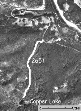
Copper Lake
 Classification: Lake
Latitude: 47.4236°
Longitude: -115.7038°
Elevation: 5185 ft.
Area: West End South
Season Start: Early Summer End: Early Fall
Difficulty: Easy to Moderate
Legal Description: T47N,R6E,sec16 ID
UTMZone: 597642, 5253040
Directions:
Take I-90 West to Lookout Pass on the Idaho-Montana border. Exit at Lookout Pass Ski Area, Exit 0. Go left over bridge then instead of going right, into the ski area, go left, down the hill for about .9 miles. Take the rutted gravel road uphill to the right. Pass the St. Regis Lakes trailhead and continue down the old railroad grade for a couple miles until you get to a pullout and trailhead on the right.
Attractions and Comments:
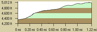
The Copper Lake trail starts up an old mining road and gains most of it's elevation in the first mile. At about the mile mark is a pile of mine tailings. The grade was gentle enough and the snow hard enough that it was still an easy hike. Copper Lake is small and brushy along the shores.
Trail Map:
|
Trail Profile:
|
The 7.5 minute series USGS topographic maps for that area
| ? | ? | Driveway Peak |
| Mullan |
Lookout Pass SW | Saltese |
| ? | ? | Adair |
Switch to TerraServer - Topo Map
Switch to TerraServer - Aerial Photo(If Avail.)
Switch to Maptech MapServer
Switch to TopoZone MapServer
Switch to TopoWest Quad MapServer