Site Information
Natural Pier Fishing Access Site
 Classification: FishAccess
Latitude: 47.0149°
Longitude: -114.5066°
Elevation: 3008 ft.
Area: Alberton
Legal Description: T15N,R23W,sec33 MT
UTMZone: 689505, 5209837
Directions:
West of Missoula on I-90 to Exit 75, south then west for 1 mile on Frontage Road. (Lat 47.015, Lng -114.507)
Alternate Directions:
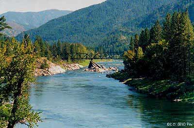
Natural Pier Fishing Access Site is located on the Clark Fork River at river mile 174 on the right hand side as you float down stream. Petty Creek is the next access site up stream from Natural Pier. St. Johns is the next site down stream from Natural Pier. Natural Pier is one of 23 FWP managed sites on the Clark Fork River.
Attractions and Comments:
Open : All Year
Trailers/RV : Site is accessible
Elevation : 2956 ft
Nearest Town : Alberton - 1 mile
Access to the river is difficult.
Narrative:
Restrictions & Closures
Weapons Discharge Prohibited
Discharge of firears prohibited - unless otherwise posted Discharge of Paint guns prohibited at all times.
KNOW BEFORE YOU GO!
Dip sites will be used on calmer water in nearby sections of the river. Fire personel will be stationed at these sites to advise recreationists about the fire suppression work and the presence of helicopters on the river. Boaters using the river should be cautious and must pull over when instructed by fire personel. Boats should pull to the side of the river until the dip is completed, stay close together, and listen to instructions. Those using fishing access sites along the Clark Fork must also keep boat ramps and launch sites clear of vehicles and open for fire crew use.
Photo:
|

The 7.5 minute series USGS topographic maps for that area
| Horsehead Peak | Stark North | McCormick Peak |
| Tarkio |
Stark South SE | Alberton |
| Williams Peak | Deer Peak | ? |
Switch to TerraServer - Topo Map
Switch to TerraServer - Aerial Photo(If Avail.)
Switch to Maptech MapServer
Switch to TopoZone MapServer
Switch to TopoWest Quad MapServer