Site Information
Sloway Campground
 Classification: Campground
Latitude: 47.2341°
Longitude: -115.0263°
Elevation: 2799 ft.
Area: Superior
Legal Description: T17N,R27W,sec15 MT
UTMZone: 649393, 5233069
Directions:
From Superior, MT, take Interstate 90 west 4.1 miles to Exit 43 at Dry Creek Rd. At end of exit ramp, turn right and go 0.3 miles to stop sign. Turn left and go 3 miles to campground on the left.
Alternate Directions:
Midway between Superior and St Regis, From I-90 take Exit 43 at Dry Creek, travel west 3.2 miles on the north frontage road, or take Exit 37 and travel 2.8 miles east.
Attractions and Comments:
Facilities: 16 campsites plus 10 trailer pull-through sites. Horse camp facilities. Cold drinking water. Host on site and boat launch.
Attractions: Near I-90, on the Clark Fork River. Volleyball net, horseshoe pits and sandbox.
Fees
Reservations: None
Open: 5/15-9/27
Directions: Midway between Superior and St Regis, From I-90 take Exit 43 at Dry Creek, travel west 3.2 miles on the north frontage road, or take Exit 37 and travel 2.8 miles east.
Altitude: 2800' elevation


Narrative:
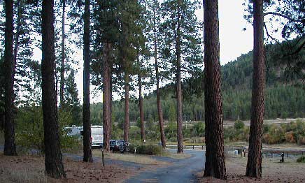
Convenient to Interstate 90, which can be heard from the campground. The campground is adjacent to Clark Fork (river) with some sites overlooking the river. It is wooded with mixed pines, mostly Ponderosa. There is a large open fenced space adjacent to campground for boarding horses overnight (a "horse motel").
There is one hitching rail. There is also a volleyball court.
NOTE: Some Forest Service literature displays the campground name as "Slowey."
SEASONS
Open Seasonal: Yes
Open All Year: No
Seasonal Comment:
Open May 18 through September 27.
RATE AND MAXIMUM STAY PERMITTED
Rate: $10 per day (see: Fees)
Maximum Stay Permitted (days): 14
CAMPGROUND SITE CONFIGURATION
No. RV Sites: 0
No. Tent Sites: 0
No. Combined Sites (Tent or RV): 27
Total Sites: 27
Tent Pads: No
Group Tent Sites: Yes
Open Sites:
No
Wooded Sites: Yes
No. Tables on Sites: 27
No. Grilles on Sites: 27
RV INFORMATION
No. Full Hookups (includes waste): 0
No. Water and Electric Only: 0
No. Water Only: 0
No. Electric Only: 0
Group RV Sites: Yes
No. RV Pull Throughs: 10
Waste Station: No
Potable Water at Waste Station: No
Average Parking Apron Size: 13' X 62'
Comments:
The parking aprons are paved. The campground will accommodate any size RV. There is a RV waste station at the Quartz Flat campground (National Forest) 10.1 miles east of Superior, MT on Interstate 90 (at the rest area) - fee $2.
FACILITIES
Vaults: Yes
Flush Toilets: No
Hot Showers: No
Wheelchair Friendly Toilets: Yes
Public Phone: No
Playground: No
No. Water Spigots: 6
No. Threaded: 1
Comments:
Threaded spigot located in "RV-only" section.
WATER SPORTS - None
Comments:
Clark Fork is a float river, but there is no put-in at the campground.
HIKING- No
FISHING
Fishing: Yes
Comments:
Rainbow and Bull Trout. Bull is catch and release.
The 7.5 minute series USGS topographic maps for that area
| Boyd Mountain | Saint Regis | Keystone Peak |
| Torino Peak |
NE Wilson Gulch | Superior |
| Sherlock Peak | Illinois Peak | Landowner Mountain |
Switch to TerraServer - Topo Map
Switch to TerraServer - Aerial Photo(If Avail.)
Switch to Maptech MapServer
Switch to TopoZone MapServer
Switch to TopoWest Quad MapServer