Site Information
Ann Arbor Trail-USFS Trail No_ 1195
Classification: Trail
Location: Forest road #342
Latitude: 47.1818°
Longitude: -115.1223°
Elevation: 36 ft.
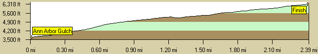
Length: 2.5Mi
End Location: 71
End Latitude: 47.2067°
Longitude: -115.1510°
End Elevation: 6318 ft.
Area: Superior
Season Start: Late Spring End:
Usage: Light
Difficulty: Moderate to More Difficult
Legal Description: Township 17N; Range 28W; Section 35
Directions:
Take I-90 to the Superior Exit, #47. Go 4.9 miles on the south side frontage road to Dry Creek Road, #342. Go 8 miles southwest on Dry Creek Road to Ann Arbor Trailhead. A hiker sign and arrow designate the trialhead.
Narrative:
This is a steep trail with some good views. It's suitable for hikers and backpackers.
Access: Hiking
Trail Profile:
|
The 7.5 minute series USGS topographic maps for that area
| Boyd Mountain | Saint Regis | Keystone Peak |
| Torino Peak |
Wilson Gulch SW | Superior |
| Sherlock Peak | Illinois Peak | Landowner Mountain |
Switch to TerraServer - Topo Map
Switch to TerraServer - Aerial Photo(If Avail.)
Switch to Maptech MapServer
Switch to TopoZone MapServer
Switch to TopoWest Quad MapServer